A recently released bulletin provides baseline mean annual evapotranspiration rates for the state of Nebraska, which in the future could show whether changes in climate have altered rates and affected water, agriculture or forestry resources.
“This is the offspring of cutting-edge research in evaporation studies utilizing the very latest advances providing regional evapotranspiration rates with an accuracy that has not been available before,” said author Joe Szilagyi, research hydrologist with the Conservation and Survey Division at the School of Natural Resources.
“Basic Meteorological Data Derived 30-year Normals (1981 - 2010) of Actual Evapotranspiration Rates in Nebraska, USA” is available for $8 from the Nebraska Maps & More Store on the first floor of Hardin Hall, 3310 Holdrege St. It also can be purchased online at marketplace.unl.edu/nemaps and amazon.com. To place an order by phone, call (402) 472-3471.
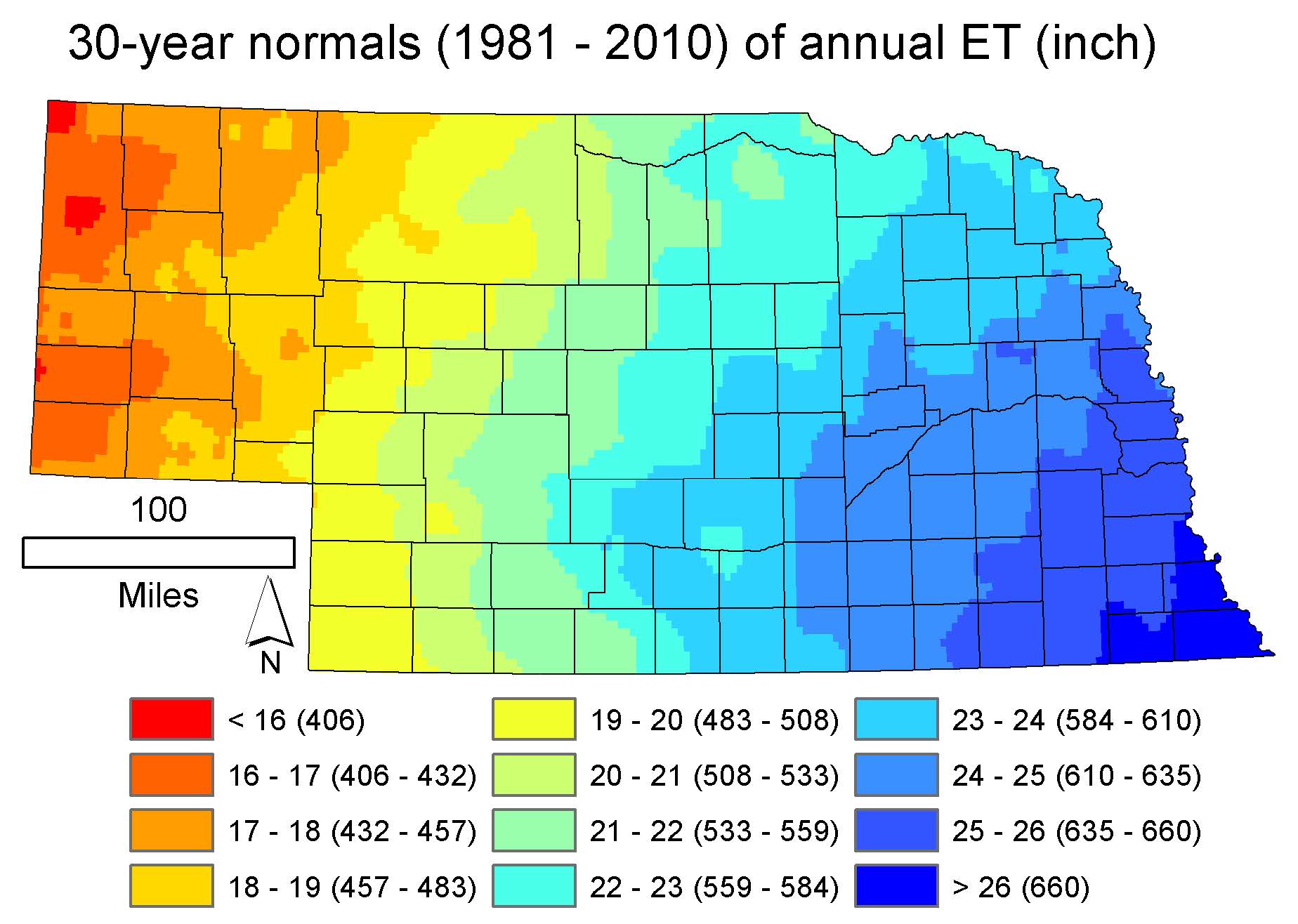
The bulletin includes mean monthly evapotranspiration and annual precipitation data for 1981 and 2010, the latest period of “climate normals” that represent the most recent three-decade average of climatological variables and provides the baseline that future values can be compared against.
“In the future, one could see if climate change altered the evapotranspiration to precipitation ratios or not either via altered ET rates, altered precipitation rates or changes in both,” Szilagyi said. “The higher the evapotranspiration to precipitation ratio, the scarcer water availability becomes for municipal, agricultural or other purposes.”
Szilagyi recently mapped evapotranspiration rates at 4-kilometer resolution for the entire contiguous United States, but made Nebraska’s results available separately to fulfill the Conservation and Survey Division’s mission of making widely available work completed in the area of geology, soils and water across the state.
Evapotranspiration is the sum of evaporation from the Earth’s surface and that from plant leaves. One of its key functions is the regulation of the surface temperature of crops, protecting them from overheating and cellular damage when temperatures are hot. Variables that affect evapotranspiration involve land use, including irrigation, and land cover in addition to air temperature, humidity, wind and available energy at the surface.
In Nebraska, the years between 1981 and 2010 show the highest rates of evapotranspiration in the extreme southeast part of the state, where precipitation levels are highest. The lowest evapotranspiration rates are in the panhandle region, where droughts remain frequent.
The Conservation and Survey Division, is the geologic and hydrologic survey component of the School of Natural Resources at the University of Nebraska-Lincoln.
Shawna Richter-Ryerson, Natural Resources