The Geography Student Organization at the University of Nebraska-Lincoln will kick off 2012 Geography Awareness Week Nov. 12-16 with a nod toward history, marking the 40th anniversary of the Center for Advanced Land Management Technology.
Geography Week also will feature a week-long photo competition, a trivia game, the annual Geography Bowl and two public lectures.
Don Rundquist, a geography and remote sensing professor in the School of Natural Resources, will present "40 years of Remote Sensing in Nebraska," on Monday, Nov. 12, at 3 p.m. in room 901 at Hardin Hall on East Campus. Rundquist began his career as a graduate student at UNL in 1972 when a NASA grant helped create the Nebraska Remote Sensing Center, renamed CALMIT in 1986.
Rundquist eventually served as the center's director for 22 years, stepping down in 2008.
"He's been more of a mentor to me," said Brian Wardlow, the current director. "He's a legend in the field, no doubt about it."
During Rundquist's tenure, CALMIT established itself as one of the premiere remote sensing facilities in the nation. CALMIT developed and adopted cutting-edge technologies, attracting some of the best scientists in the world, and training a generation of professionals in the fields of remote sensing and Geographic Information Systems.
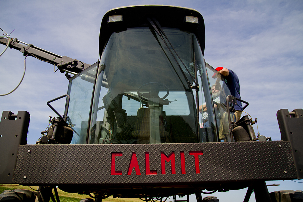
Perhaps CALMIT's greatest strength is its ability to perform sophisticated lab work and also make high-level field observations that can be linked to aircraft and satellite remote sensing observations. They can then use that information to develop practical remote sensing applications in the field with hand-held instruments, or by using sensors mounted on heavy equipment, aircraft, or satellites. Such capacity allows a more complete and detailed picture of agricultural and natural resources, practical information that can be used by both researchers and decision makers to gain insight into what is happening with an individual plant, a field, a landscape, or much larger areas such as a state or the entire country
"That's what distinguishes us," Wardlow said. "Not everybody has that lab ability to conduct both basic and applied remote sensing research across this full continuum of spatial scales."
More recently, CALMIT researchers have developed algorithms that can decode the millions of bits of data that stream through monitoring satellites. Such applications help people get a better sense of things like groundwater levels, the consumption of water by plants or even the overall health of crops across the nation.
Rundquist said CALMIT's ability to measure crop health from space is largely the product of work by Anatoly Gitelson, who came to UNL in 2000. He developed crop yield and status models now used around the world.
Rundquist's first doctoral student, LLoyd Queen, will return to UNL to present Geography Week's second seminar. Queen, the director of the National Center for Landscape Fire Analysis at the University of Montana, will address the Hardin Hall Auditorium at 3:30 p.m. on Wednesday, Nov. 14. His talk is titled, "Characterizing Fire-on-Fire Interactions in three Large Wilderness Areas Using the Monitoring Trends in Burn Severity (MTBS) Fire Perimeter Data."
Events for Geography Awareness Week:
-- Photo Competition: Entrants will be on display in the Hardin Hall lobby all week. The winner will be determined by a student vote and a panel of judges. Results will be announced in room 228 on Friday, Nov. 16, at 2 p.m.
-- Geography Wheel Game: Available each day of the week from 11 a.m. to 1 p.m. in the City Campus Union. Participants spin the wheel and are quizzed about their geographic knowledge for a chance to win a prize.
-- Seminar: Don Rundquist will address "40 Years of Remote Sensing," on Monday, Nov. 12, at 3 p.m. in Hardin Hall room 901.
-- Geography Bowl: Held Tuesday, Nov. 13, in the Hardin Hall Auditorium at 6-9:30 p.m. More than 100 students are expected to turn out for this popular geography quiz tournament. Each member of the winning team will receive a geocaching kit, donated by Garmin and the UNL Geography Program. Free pizza and door prizes will also be provided by the Geography Program and various Lincoln establishments.
-- Seminar: LLoyd Queen will address "Characterizing Fire-on-Fire Interactions in three Large Wilderness Areas Using the Monitoring Trends in Burn Severity (MTBS) Fire Perimeter Data," on Wednesday, Nov. 14, at 3:30 p.m. in the Hardin Hall Auditorium.
Photo Caption: CALMIT uses some heavy equipment as a platform for sensors at the Agricultural Research and Development Center near Mead, Neb. , like this repurposed farming rig, "Hercules." CALMIT will celebrate its 40 anniversary during Geography Awareness Week Nov. 12-16.