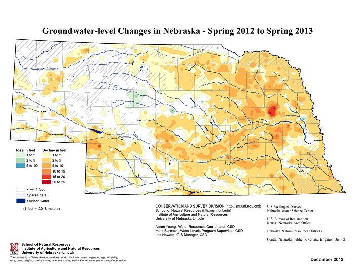
The recently released 2013 Nebraska Statewide Groundwater-Level Monitoring Report reveals significant groundwater level declines throughout Nebraska.
"Almost the entire state — with the exception of a small area in the Sandhills — saw declines last year," said Aaron Young, groundwater resources coordinator at UNL. "And even then, I would suspect that in the next year or two we're going to see some substantial groundwater level declines in the Sandhills as well."
From spring 2012 to spring 2013, every county in Nebraska experienced a water-level decline greater than one foot with the exception of Grant, Hooker and Thomas Counties. Some parts of Nebraska saw one-year water level changes of almost 25 feet.
"That is unprecedented since we have been keeping records for water-level changes," Young said.
Groundwater-level monitoring began in Nebraska in 1930. The annual reports and maps have been produced by the Conservation and Survey Division in the School of Natural Resources at UNL since the 1950s. The latest report was released Jan. 30.
On average, groundwater levels in Nebraska declined 2.54 feet from spring 2012 to spring 2013 as the result of increased groundwater pumping, and decreased recharge from precipitation.
"An average one-year decline of this magnitude has never been recorded before in the state," Young said.
Drought conditions in Nebraska during 2012 – the worst ever recorded in the state – created a heavy demand for irrigation water to keep crops alive. According to the High Plains Regional Climate Center, precipitation values for the state were 12-16 inches below normal for Nebraska, with the highest average temperatures ever recorded.
"The extreme drought resulted in dry wells, municipal water shortages and water restrictions throughout the state," Young said.
Statewide groundwater-level monitoring reports depict the change in water levels from spring to spring at different time scales. The reports study the rates of drawdown and recharges measured in regional wells, and give a general depiction of the current state of groundwater levels on a yearly basis. The reports also compare historical trends of regional water levels over extended periods of time. Collecting data is a collective effort between the United States Geological Survey, U.S. Bureau of Reclamation, Nebraska Natural Resources Districts and Central Nebraska Public Power and Irrigation District.
The 2013 Nebraska Statewide Groundwater-Level Monitoring Report is $12 and available for purchase from the Nebraska Maps and More Store on the first floor of Hardin Hall. The book can also be purchased online at http://nebraskamaps.unl.edu. To place an order by phone, call 402-472-3471. The report is available online as a PDF at http://go.unl.edu/groundwater.
— Mekita Rivas, Natural Resources
More details at: http://go.unl.edu/42yo