In case you missed it, national news organizations have been ramping up coverage of the current El Nino event that is rapidly intensifying in the Equatorial Pacific. The latest three-month (April-June) sea surface temperature anomaly for this region was 0.9°C above normal. Based on the Climate Prediction Center table of past El Nino and La Nina events, there have been only three instances since 1950 when temperature departures have been this large during April-June.
Looking back at historical CPC records, an April-June temperature departure reading of 1.0°C was recorded in 1983 and 1992, while 1987 came in at 0.9 °C. It should be noted that the 1983 and 1992 events were decaying and had disappeared before the end of the summer. The 1987 value represented the low value between the peaks of the 1986-87 and 1987-1989 back-to-back El Nino events.
The strongest El Nino recorded since 1950 occurred during 1997-98 and had a subsequent basin average sea surface temperature departure of 0.6°C above normal for the comparable April-June period. Our current El Nino event is 0.3°C warmer than this record-setting event and forecasted to be one of the strongest, if not the strongest El Nino is our climatological data base.
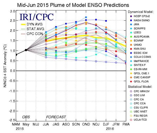
CPC's latest El Nino advisory indicates that mean peak of this El Nino is forecasted to occur during the October-December (Figure 1). The peak temperature deviation estimate by the 25 models used to forecast El Nino indicates an average of 1.7°C above normal. The 1997-98 event peaked out at 2.3°C above normal, but at least five of the models used for projecting this El Nino's peak show a cooling trend moving forward. Throw these five projections out and the average peak deviation value increases to 2.0°C above normal.
We already seeing early signs of environmental relationships usually found with strong El Nino events. Hurricane activity has been able to move much further northward in the eastern Pacific than normal bringing rainfall to southern and central California. The southwest monsoon season has brought heavy rainfall and flash flooding to the lower Great Basin region. Pacific crab species that are usually found well south California are covering beaches as they wash ashore.
Based on available information, there is a high probability that California will experience a very aggressive precipitation pattern through spring 2016 and significant recovery to the lower Colorado River system is likely. As we move into late fall and winter, the southern Plains will likely experience wet conditions and periodic bouts of severe weather in the form of rain, snow and ice.
— Al Dutcher, Nebraska Climate Office
More details at: http://go.unl.edu/j0sy