According to a May 24 Bloomberg article, the Australian Bureau of Meteorology (ABM) has declared the current El Nino pattern over and issued a La Nina watch as the Equatorial Pacific rapidly cools to below normal temperatures. ABM indicates that most of their models call for La Nina development within the June–August time frame. The U.S. Climate Prediction Center (CPC) places the odds of La Nina developing before the end of this summer at 55%, down from 70% last month.
It should be noted that the methodology used to determine if a La Nina event is ongoing differs between these two weather agencies. CPC includes sea surface temperature deviations, while ABM looks at the pressure difference across the Equatorial Pacific to determine El Nino, La Nina, or neutral conditions. In fact, ABM reported a weak El Nino event last winter, while the CPC didn’t think indicators were met.
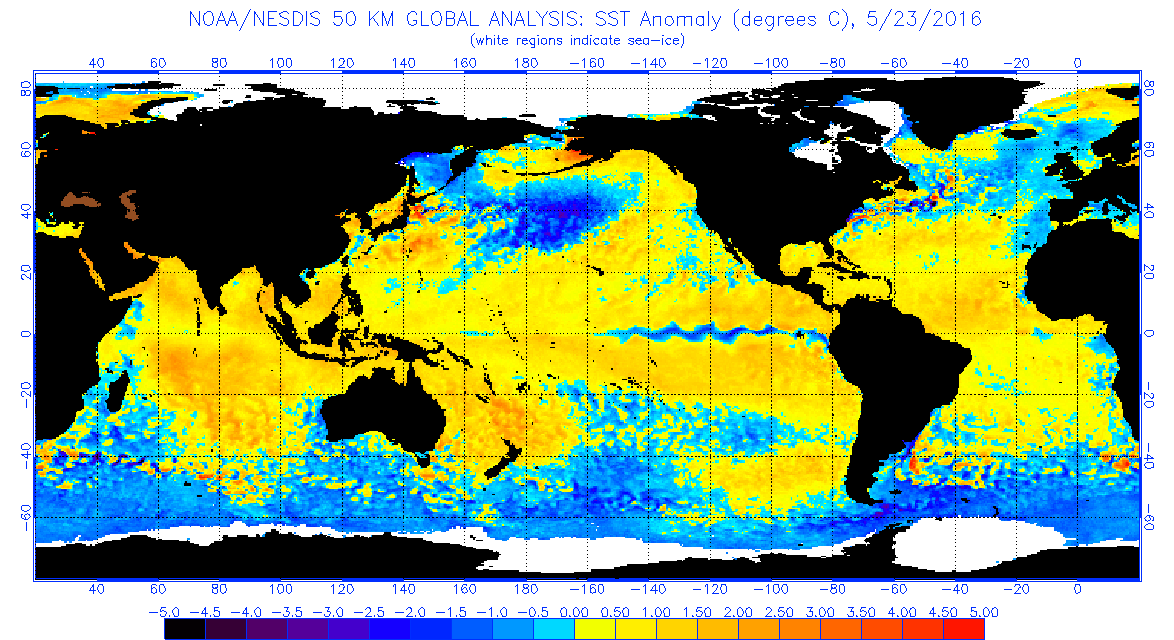
Map of sea surface temperature anomalies
Figure 1. Global sea surface temperature anomalies. (Source: NOAA Office of Satellite and Product Operations)
Current sea surface temperature deviations (Figure 1) indicate that below normal temperatures cover the eastern two-thirds of the Equatorial Pacific, but the area is still concentrated between 2 degrees north and south of the Equator. However, a substantial area of below normal temperatures under the Equatorial Pacific extends from Indonesia to South America. This would support a continuation of cooling along the Equator and a gradual strengthening through the summer and into the fall (Figure 2).
As I mentioned in my early May CropWatch article, the Equatorial Pacific is cooling rapidly and it would not surprise me at all if La Nina conditions developed before the end of June. It appears that the ABM models are pointing toward a similar conclusion. If the ABM forecast comes to fruition, we will need to pay particular attention to whether this supports the development of a high pressure over the western half of the United States.
chart of sea temperature anomalies
Figure 2. Depth-longitude section of equatorial Pacific upper-ocean (0-300m) temperature anomalies ( C) center on the pentad of May 3, 2016. The anomalies are averaged between 5 N-5 S. Anomalies are departures from the 1981-2010 base period pentad means. (Source: NOAA: Climate Prediction Center)
Weather Implications from the End of This El Nino
An active storm pattern has developed across the central and southern High Plains region during the last five weeks, as our recent El Nino event began to rapidly weaken. Above normal moisture and snowfall were also common across the central Rockies, the headwater region for the Platte watershed. This late surge of moisture is not unexpected and CPC statistics of past El Nino events point to an above normal moisture tendency in the March-May period centered over Kansas and Nebraska.
Snowpack levels in the upper reaches of the North Platte basin continue to remain above normal with locations in northern Colorado and south central Wyoming running 150-300% of normal. Based on current information from the Natural Resource and Conservation Service, water in the remaining snowpack is at 6 and 10 inches. Therefore, we are likely looking at several more weeks of snowmelt before the runoff season comes to an end.
Reservoirs on the northern branch of the Platte have about 288,000 acre/ft of storage available before flood pool is reached. With such a large snowpack still remaining for this time of the year, it may be challenging to minimize downstream flood potential in central and eastern Nebraska while trying to manage the runoff in combination with the actively wet pattern that is firmly established across the central Plains.
A couple of weeks of dry weather would certainly alleviate potential flood concerns, but current weather models offer no short-term relief from the current wet pattern. There are hints of a brief respite from the daily thunderstorm activity at the beginning of June, but models bring back the aggressive moisture pattern as early as next weekend. As I have noted numerous times in the past, above normal snowpack levels usually translate into above normal moisture trends in the central High Plains region.
US map June-August temp outlok
Figure 3. Three-month outlook for precipitation valid for June-August 2016. "A" indicates area of above normal precipitation, averaged over the three-month period. (Source: NOAA Climate Prediction Center)
US map of August-October precip outlook
Figure 4. Three-month outlook for precipitation valid for August-October 2016. "B" indicates area of below-normal precipitation, averaged over the three-month period. (Source: NOAA: Climate Prediction Center)
Summer and Fall Forecasts
If we look at CPC forecasts for the summer and fall, two distinctly opposite trends are apparent. First, all of Nebraska is included in an above-normal precipitation forecast for June and June through August (Figure 3). However, the August through October forecast (Figure 4) indicates drier than normal conditions for Nebraska. In both forecast figures, western Nebraska has been assigned the highest probabilities for these events. (Note: These forecasts indicate dominant trends representative of the three-month average. Within that three-month period, there could be significant swings and sustained variations from the dominant trend. For example, extremely heavy rains the first month could overshadow a drier trend for the next two months, leading to a forecast of above-normal precipitation for the three-month period.)
The CPC forecast is directly tied to their El Nino and La Nina statistics. El Nino conditions generally bring above normal moisture to the central High Plains as they dissipate during the spring. La Nina conditions usually favor drier than normal conditions during the fall before the event reaches its peak. If the event develops before the end of the summer, this drier than normal scenario can develop during the summer.
If the Australian Bureau of Meteorology is correct with their La Nina forecast, I anticipate that a drier pattern will begin to develop during the second half of the summer. Hopefully we will get a few days of dry conditions between rain episodes to promote adequate root development on crops. We certainly don’t need to be put in a position where crops develop shallow roots, then suffer moisture stress due to roots not growing more than a couple feet below the surface.
We also should pay attention to the upper Great Lakes region where drier than normal conditions have developed over the past three to four weeks. Much of this dryness has been masked by recent cool temperatures, but deficits of 2-4 inches are currently being reported across portions of eastern Iowa, Wisconsin, Minnesota, and Michigan.
Systems that have impacted our weather have lost a lot of their punch as they moved northeast of Nebraska. Storm activity has consistently weakened, moving into dry, cool, and stable air over the Great Lakes. Precipitation shortfalls this early in the growing season don’t appear to be causing problems.
With some lingering impacts from our El Nino event still present in the atmosphere, this area may see an expansion of dryness through June. It will be interesting to see if the development of La Nina conditions brings a quick end to the eastern Corn Belt dryness or if the recent dry pattern strengthens and deepens.
-- Al Dutcher, Associate Nebraska State Climatologist for CropWatch
More details at: http://go.unl.edu/ruf2