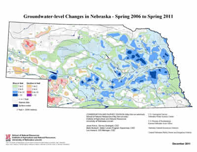
Groundwater levels rose or were unchanged throughout much of Nebraska over the past year, but over the past 30 years, there have been markedly different changes in eastern Nebraska compared to western Nebraska.
The latest statewide groundwater monitoring report by the University of Nebraska-Lincoln’s Conservation and Survey Division (CSD) shows mixed results, depending on where and over what period of time groundwater levels are measured, but over the past five years, and especially over the past year, the news for Nebraska’s groundwater levels is generally pretty good.
“The five-year period from spring 2006 to spring 2011 was characterized by groundwater level rises in almost all areas of the state except the Southwest and Panhandle Tablelands,” CSD and UNL School of Natural Resources (SNR) groundwater geologist Jesse Korus said.
Over just the past year, from spring 2010 to spring 2011, 70 percent of the wells monitored for the report indicated rises in groundwater levels, with 36 percent showing rises of more than a foot. Only 11 percent of monitored wells showed declines of more than a foot.
“The (groundwater level) rises over the past five years are a result of a combination of factors, including increased flows in streams and canals, decreased irrigation withdrawals and increased aquifer recharge compared to the several dry years prior to 2006,” said SNR geoscientist Mark Burbach, who co-authored the report with Korus and CSD cartographer Les Howard.
“Nebraska Statewide Groundwater-Level Monitoring Report 2011,” is the latest in a series of groundwater-level change maps and reports dating to 1954.
The 23-page illustrated report details and maps changes in Nebraska groundwater levels from Spring 2010 to Spring 2011, over the past five years and 10 years, from predevelopment of irrigation to Spring 2011 and new with this report: from predevelopment to spring 1981 and spring 1981 to spring 2011. It also includes average daily streamflows in 2010 and other related information.
The report’s authors chose to include maps comparing periods before and after 1981 because “Several recorder wells in south-central Nebraska show markedly different patterns of groundwater level fluctuations during these two periods, and we wanted to investigate whether or not these patterns were consistent statewide,” Korus said.
“Up to 1981 groundwater declines were generally equal in magnitude in eastern and western areas of the state,” Korus said.
In general, the 30-year period after 1981 shows some significant rises in groundwater levels in the eastern half of the state, with equally significant declines in some areas of the Panhandle and Southwest Nebraska.
“Some, but not all of these trends are reflective of statewide precipitation patterns compared to the long-term norms,” Korus said, “The hypothesis is that the post-1981 recovery of groundwater levels in central and eastern Nebraska resulted from a combination of factors, including reduced (groundwater) withdrawals during several long periods of above-average precipitation, increased irrigation efficiencies, increasing rates of recharge and the aquifer equilibrating to the new conditions imposed on it by irrigation development decades earlier.”
Overall, from predevelopment (of irrigation) to spring 2011, the “Long term groundwater level changes in Nebraska primarily reflect aquifer depletion in areas of dense irrigation development and increases in storage due to seepage from canals and reservoirs,” Burbach said.
Predevelopment water levels are estimated, but generally occurred before the early to mid-1950’s depending on when intensive groundwater irrigation began.
Average daily streamflows across Nebraska also got a considerable boost from above-average precipitation over much of the state in 2010.
“Average daily streamflows were higher than the 30-year average for most of Nebraska’s streams in 2010,” Korus said. Highest discharges occurred in some tributaries to the Republican, Elkhorn, North Platte, White and Little Nemaha Rivers.
Groundwater level change maps included in the report can be downloaded free at the SNR web site at http://snr.unl.edu/data/water/groundwatermaps.asp. Maps from previous years, dating to 1954, are also archived there. Efforts to monitor the state’s groundwater levels began in 1930.
Data for the maps, graphs and reports is based on recorded measurements from more than 6,000 observation wells taken by 27 organizations, including each of Nebraska’s 23 Natural Resources Districts, U.S. Geological Survey, Central Nebraska Public Power and Irrigation District, U.S. Bureau of Reclamation, and CSD.
Groundwater level change maps rely on well readings recorded as close to April 1 as possible, before the start of the irrigation season.
The full report, “Nebraska Statewide Groundwater-Level Monitoring Report 2011,” (Nebraska Water Survey Paper Number 79), can be purchased for $15 online at both snrsales@unl.edu or Amazon.com or at the Nebraska Maps and More store, first floor Hardin Hall, UNL East Campus, N. 33rd and Holdrege streets, Lincoln.
-- Steve Ress, Nebraska Water Center
More details at: http://go.unl.edu/q2m