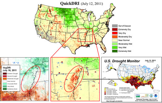
Researchers associated with the School of Natural Resources and the National Drought Mitigation Center are leading a four-year NASA-funded project to develop the Quick Drought Response Index, or QuickDRI. It will complement VegDRI by detecting drought's effects on vegetation at time intervals of a month or less.
VegDRI, now an operational tool with a map released every week or every two weeks, shows the effects of drought on vegetation at seasonal scales, based on data from remote sensing, climate observations and static biophysical variables such as land use. The fast-onset "flash" drought in 2012 highlighted the need for tools to detect fast-moving drought.
"One of the outcomes we are hoping to achieve with a tool/ product like QuickDRI is to help us monitor and detect flash droughts," said Mark Svoboda, leader of the NDMC's Monitoring Program Area. "These tend to sneak up on us and can have major environmental, agricultural or fire impacts. The timing of droughts is a critical component in assessing their overall magnitude and potential impacts."
After a one-year feasibility study yielded promising results, the QuickDRI research team received $1.3 million for a three-year project to turn QuickDRI into an operational tool. The grant award is from NASA's Applied Sciences for Water Resources program, led by Bradley Doorn.
"We were able to leverage previous experience and partnerships to move forward," said Brian Wardlow, director of the Center for Advanced Land Management Information Technologies at the University of Nebraska-Lincoln. Wardlow, who is affiliated with the National Drought Mitigation Center, also based at UNL, and Svoboda are the principal investigators, and Tsegaye Tadesse, NDMC climatologist, is also on the project.
Partners include Martha Anderson of the U.S. Department of Agriculture's Agricultural Research Service and Chris Hain at the University of Maryland, who produce the Evaporative Stress Index (ESI); Jesslyn Brown with the U.S. Geological Survey's Earth Resources Observation and Science Center; and Matthew Rodell, at NASA's Goddard Space Flight Center, who produces groundwater maps based on data from the GRACE satellites. The maps are on the NDMC's website.
"We're building on the VegDRI experience," Wardlow said. "The VegDRI concept was developed more than a decade ago," when there were very few long-term records of satellite data to work with. "Since then, other products and histories have become available that will allow us to have a more rapid response indicator of agricultural drought."
With QuickDRI, "We're trying to integrate data along a vertical column," Wardlow said. Above ground, QuickDRI will use the Normalized Differentiated Vegetation Index (NDVI), as does VegDRI, to detect plant condition. On the Earth's surface, QuickDRI will incorporate the ESI, which reflects boundary layer conditions, that is, evaporative moisture loss from plants. Below ground, QuickDRI will use data from GRACE satellites, which shows how much moisture is in plants' root zones.
QuickDRI may also make use of the Standardized Precipitation Evaporation Index, which incorporates a calculation of evaporation by taking both temperature and precipitation into account, instead of just precipitation. The Standardized Precipitation Index is calculated based solely on precipitation. Whereas VegDRI uses a 6- or 9-month SPI, QuickDRI will use a 3-month SPI or SPEI, Wardlow said.
Incorporating a temperature variable will give a fuller picture of drought's effects on vegetation. "If you've got a dry, cool spring, the SPI might be showing moderate to severe drought, but crops and lawns are not showing much stress because there's not as much demand for moisture," Wardlow said. Evaporation from plants is slower in cooler weather, and stored moisture in the soil may be sufficient. "Dry and cool means something different than if it's dry and hot," he said. "We're hoping to get a truer representation of agricultural conditions with this model."
"Our traditional climate-derived drought indicators don't always do the best job of seeing the relationship and interplay between precipitation, soil moisture, temperature and potential evapotranspiration and their impact on crops and the environment," Svoboda said. "Satellites and their early detection of plant stress help us bridge the gap between climate-based indicators and newer vegetation indices."
He added that satellite-derived indicators are critical for augmenting ground-based observation networks, which, he said, "will never be as dense as we need them to be."
The project will incorporate feedback from users throughout, and QuickDRI will have the advantage of a pre-established user community from VegDRI, Wardlow said. Users include U.S. Drought Monitor authors, the Bureau of Land Management, and many other land and resource managers at state agencies and various organizations.
Svoboda, who is also a U.S. Drought Monitor author, said, "This tool could really help fill a gap in our nation's drought early warning capacity for these rapid onset types of drought."
— Kelly Helm Smith, National Drought Mitigation Center
More details at: http://go.unl.edu/tqzz