Groundwater levels in the spring of 2016 continued to rise following above-normal and near-average precipitation recorded for the year across the state, but many parts of the state still saw groundwater levels remain below spring 2012 levels, according to the 2016 Nebraska Statewide Groundwater-Level Monitoring Report.
The Conservation and Survey Division at the School of Natural Resources, University of Nebraska-Lincoln, recently released the report, which examines groundwater level changes, using data collected from nearly 5,000 wells across the state. It studies the rate of drawdown and recharge measured in regional wells and gives a general depiction of the current state of groundwater levels on a yearly basis. It also looks at historical trends, comparing regional water levels over extended periods of time.
The report is available for $7 from the Nebraska Maps and More Store in the lobby of Hardin Hall, 3310 Holdrege St., or is available online at marketplace.unl.edu/nemaps or amazon.com. Phone orders also are accepted at 402-472-3471. A PDF of the report can be downloaded at go.unl.edu/groundwater.
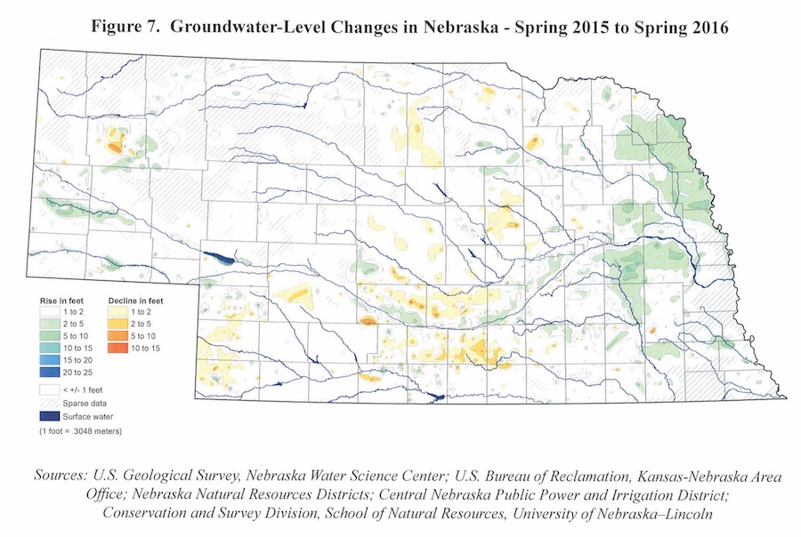
The authors of this year’s annual report found water levels rose on average 0.69 feet from spring 2015 to spring 2016, with significant rises in the Panhandle, along the Platte River Valley and the eastern one-third of the state. The rest of the state saw near-average precipitation and modest, localized water level changes.
Although the one-year rises look good, many parts of the state remain below 2012 levels, when drought hit the state and lasted through spring 2013. During that time, Nebraska saw significant groundwater level declines. In much of eastern and central Nebraska groundwater levels are still 10 to 15 feet below 2012 conditions. However, if the state continues to see above-average precipitation, as it did last year, groundwater drawdowns will continue to be reduced.
In-depth maps in the report look at one-year groundwater level changes, but also examine five-year and 10-year changes, in addition to changes since the beginning of irrigation development. The maps are based on information collected by the Conservation and Survey Division, U.S. Geological Survey, U.S. Bureau of Reclamation, Nebraska Natural Resources Districts and Central Nebraska Public Power and Irrigation District. The reports and maps are produced by the Conservation and Survey Division and have been since the 1950s. Groundwater monitoring began in Nebraska in the 1930s.
Authors of this year’s report are Aaron Young, survey geologist; Mark Burbach, environmental scientist; Leslie Howard, geographic information science and cartography manager; Michele Waszgis, research technician; Matt Joeckel, state geologist and CSD associate director; and Susan Olafsen Lackey, research hydrogeologist.
For more information on groundwater or groundwater maps, visit go.unl.edu/groundwater.
For more information on the report or associated studies, contact Aaron Young at 402-472-8339.
Shawna Richter-Ryerson, Natural Resources
More details at: http://snr.unl.edu