The School of Natural Resources now has 10 Global Positioning System units for use in class or research. Faculty and staff can reserve them through the SNR resources system and can check them out from the front desk staff at Nebraska Maps and More in the first floor lobby of Hardin Hall.
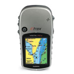
The Garmin eTrex Vista HCx GPS units are high sensitivity, meaning they will work under tree canopies and sometimes even indoors. They have a color screen and use an SD micro memory card, and are in two brightly colored, easy-to-find protective cases that float in water if they're closed.
The eTrex Vista receivers are WAAS-enabled – that stands for Wide Area Augmentation System -- and pick up signals from at least five satellites to pinpoint a location within 10 feet. WAAS is a system of satellites and ground stations that correct GPS signals to provide more accurate locations.
Each receiver is loaded with 770 topographic maps of the central United States, including all of Colorado, Kansas, Nebraska, South Dakota and North Dakota, and parts of Iowa, Minnesota, Missouri, Montana and Wyoming. Other maps can be loaded, too, with enough lead time.
"GPS is one of the most rapidly advancing technologies we have today," said Bryan Leavitt, the SNR research systems analyst who maintains the devices. "It's important for students to be up to date when they leave."
Mobile GPS receivers use the signals from the NAVSTAR network of satellites to identify a precise location. NAVSTAR, originally developed by the Department of Defense, is now available internationally for civilian uses. Leavitt noted that GPS is now integral to aviation navigation, trucking, the power industry, and is in most cell phones and many automobiles. GPS has become so vital that a number of countries are establishing or augmenting GPS systems. These include Russia, China, Japan, the European Union, and India.
"If GPS were to go away right now, the impact on the worldwide economy would probably be in the hundreds of billions to trillions of dollars," Leavitt said.
Closer to home, he said, SNR researchers have used GPS to map the boundaries and find the area of ponds, identify nesting positions of birds, ensure that fish counts on different days are conducted at the exact same spot on a lake, locate wells, track animal movements, use precision agriculture, and more.
GPS mapping is incorporated into various classes and research projects at SNR, and students can take Leavitt's course, Introduction to the Global Positioning System, NRES or GEOG 427. Students in 427 will also be able to use SNR's new high-end GPS receivers that can pinpoint a location to within 4 inches. They are GeoXH handhelds, manufactured by Trimble.
Questions? Please contact Bryan Leavitt, 325 Hardin Hall, 402-472-8179, bleavitt2@unl.edu.