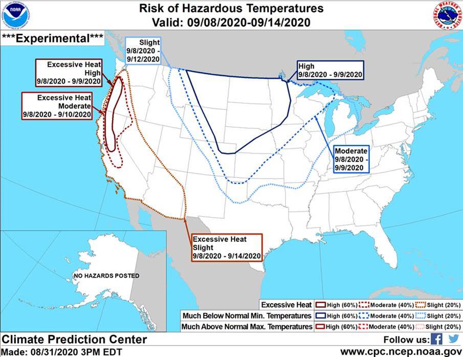
The NOAA Climate Prediction Center (CPC) is forecasting a moderate to high risk of much-below normal temperatures on September 8 & 9 for much of the Northern to Central Great Plains region. In this high-risk area, there is a 60 percent chance of minimum temperatures falling to freezing or lower, and below the 15th percentile (that is, only 15 out of the past 100 years have seen colder temperatures on these dates; or said another way, the expected temperatures on Sept 8 & 9 will be lower than those observed in 85 out of the past 100 years during these same dates).
On Sept 8, there is also a slight risk of high winds (gusts above 40mph) for the Great Plains, which could make temperatures feel even colder for humans, livestock, pets, etc.
Regarding precipitation, NOAA CPC is not currently expecting any to accompany this cold-front. However, please check the weather forecast regularly as Sept 8 & 9 approaches, especially if you live or work at higher elevations where any precipitation that may fall (although not currently forecasted) could arrive as snow instead of rain.
The map below shows which areas are at moderate to high risk of much-below normal temperatures. Note that areas shown as “high” risk are most likely to experience a freeze. For Nebraska, the Dakotas, and northeast Colorado if a freeze were to occur on Sept 8 or 9, this would be a couple of weeks earlier than normal.
Please share this alert with any stakeholders whose crops, livestock, gardens, pets, irrigation systems, etc., might be vulnerable to an early freeze. Example concerns might include the following—this is not an exhaustive list, so please help identify any other possible concerns or vulnerabilities:
livestock still grazing in the high-country, which might try moving to lower elevations or elsewhere to seek shelter from the cold;
fall-calving operations with newborn or young animals, which might need additional shelter or insulation from the cold;
calves that are being weaned just ahead of or during the cold-snap on Sept 8 & 9 might experience higher levels of stress than normal;
livestock might have higher energy requirements during the cold-snap, especially those lacking a winter coat or already stressed from drought conditions;
pets that live outdoors or spend extended amounts of time outside, which might need additional food, shelter, or insulation from the cold;
cover crops or other fall-planted crops that germinate before the potential freeze on Sept 8 & 9 might suffer freeze-damage;
unharvested vegetables and fruits, and temperature-sensitive horticultural plants, might suffer freeze-damage;
irrigation systems that have not yet been drained might be at risk of freezing;
water hoses that have not been detached from outdoor spigots might be at risk of freezing and causing pipes to break;
other risks to crops, gardens, pets, livestock, and infrastructure not identified here.
To read the official NOAA CPC Hazard report, visit https://www.cpc.ncep.noaa.gov/products/predictions/threats/threats.php.
Between now and Sept 8 & 9, please consult your nearest NWS (National Weather Service) Forecast Office’s website regularly for short-range weather forecasts for your local area.