The Conservation and Survey Division in UNL's School of Natural Resources recently led a drilling project near Hyannis, Nebraska that resulted in the organization's third deepest test hole ever.
"The Hyannis West site was our deepest test of the project, which terminated at 1,721 feet," said Doug Hallum, survey hydrogeologist. "Within the current test hole database, this test represents the third deepest CSD test hole to date."
Even in the thickest part of the High Plains Aquifer – where the drilling took place – a test hole rarely exceeds 1000 feet. The deepest test hole on record is approximately two miles southeast of the Hyannis West location and will be used for comparative purposes regarding the geology and geophysical logging that was completed at each site.
"This test was unique not only for its depth, but for a number of other factors," Hallum said.
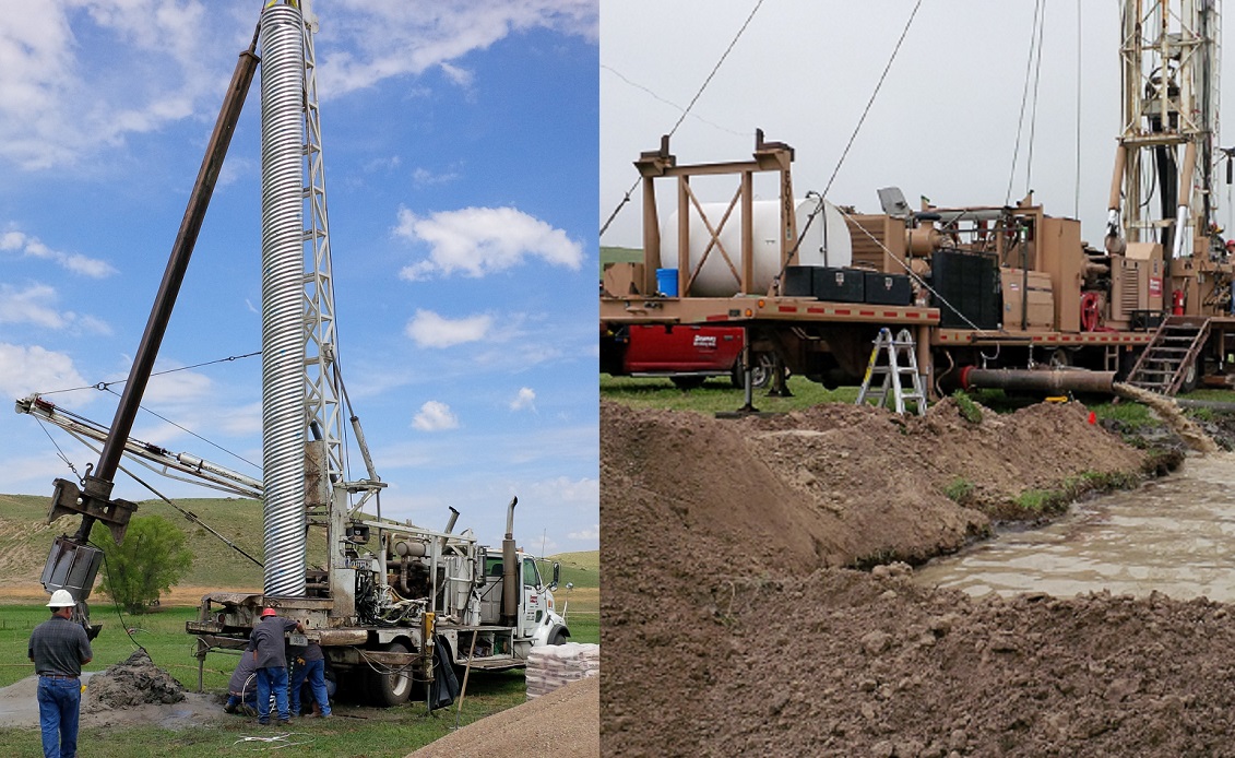
As opposed to employing the typical mud rotary technique, the test used the reverse rotary technique as its primary drilling method.
"The reverse rotary technique was used with the idea that it would improve sample quality and quantity and deliver them to the surface more quickly than mud rotary, which was confirmed during the test," Hallum said.
Samples from more than 1500 feet below land surface were collected within four minutes of cutting them – more than three times faster than what the mud rotary technique would have produced. Additionally, the samples were delivered in discrete packages capable of discerning changes over only a foot or two, which is nearly impossible using the mud rotary technique, Hallum said.
"(Reverse rotary) is generally more expensive and requires a surface casing, but when test holes are deep – or samples need to be sufficiently discrete – it can be a very effective method to ensure the highest quality results," he said. "Samples were some of the best ever collected from depths exceeding 1000 feet."
The weeklong project faced its share of hurdles and required the multiagency support of the CSD, the Nebraska Department of Environmental Quality, Nebraska's Natural Resources Districts, drilling contractor Downey Drilling, Inc., and the local community.
"Landowner stewardship is key," Hallum said. "The reverse technique requires a relatively large site and a lot of disturbance, so finding a landowner willing to allow the work was a fundamental challenge, one that was addressed by constant collaboration with our local partners (at) the Natural Resources Districts."
Additionally, unpredictable working conditions created challenges.
"The team tolerated a variety of weather," Hallum said. "(We were) hiding from hail, sheltering from sun, breaking the wind with our vehicles and working wet when we weren't quick enough to find shelter or rain gear."
Hallum and Jim Goeke, emeritus research hydrogeologist, coordinated the scope of the test hole work in western Nebraska. Sue Lackey, associate geoscientist, led the eastern Nebraska efforts.
"The NDEQ requested that the CSD assist them with the development of a statewide groundwater quality monitoring network by assessing the hydrogeology across the state through the completion of test holes," Hallum said.
Those test holes – including the one at 1,721 feet – will be used to provide recommendations to the NDEQ relating to potential monitoring well design.
"The project includes many test holes – past and present," Hallum said. "The broader objectives of the project are many and specific to each of the collaborating parties."
The CSD, in particular, is interested in learning more about the High Plains Aquifer, refining the conceptual model of the High Plains Aquifer, understanding the relationships between the shallow and deep aquifers of the state, and understanding relationships between deep aquifers in the west and the occurrence of uranium.
"Now we'll share what we learned and demonstrate where it will be useful to employ the techniques in the future, then we'll do it again to generate more useful information," Hallum said. "Hopefully, we'll also improve our test hole database and our sample archive, and continue to assess our techniques to be confident that we're generating the best science possible for the people of Nebraska."
The Nebraska statewide test hole database contains information on approximately 5,500 test holes drilled since 1930 by the CSD, SNR, the university and cooperating agencies. It can be accessed online at http://go.unl.edu/w9w9.
— Mekita Rivas, Natural Resources