One year ago, a historic flood struck Nebraska, topped levees and took out bridges, dams, and houses, covering thousands of acres of Nebraska in water and reminding Nebraskans of the power of a raging river.
But destructive floods in Nebraska’s ancient past have also shaped the geology of the state, forming bouldery rocks in the rim of the Wildcat Ridge of western Nebraska, finds a recent study by University of Nebraska-Lincoln researchers.
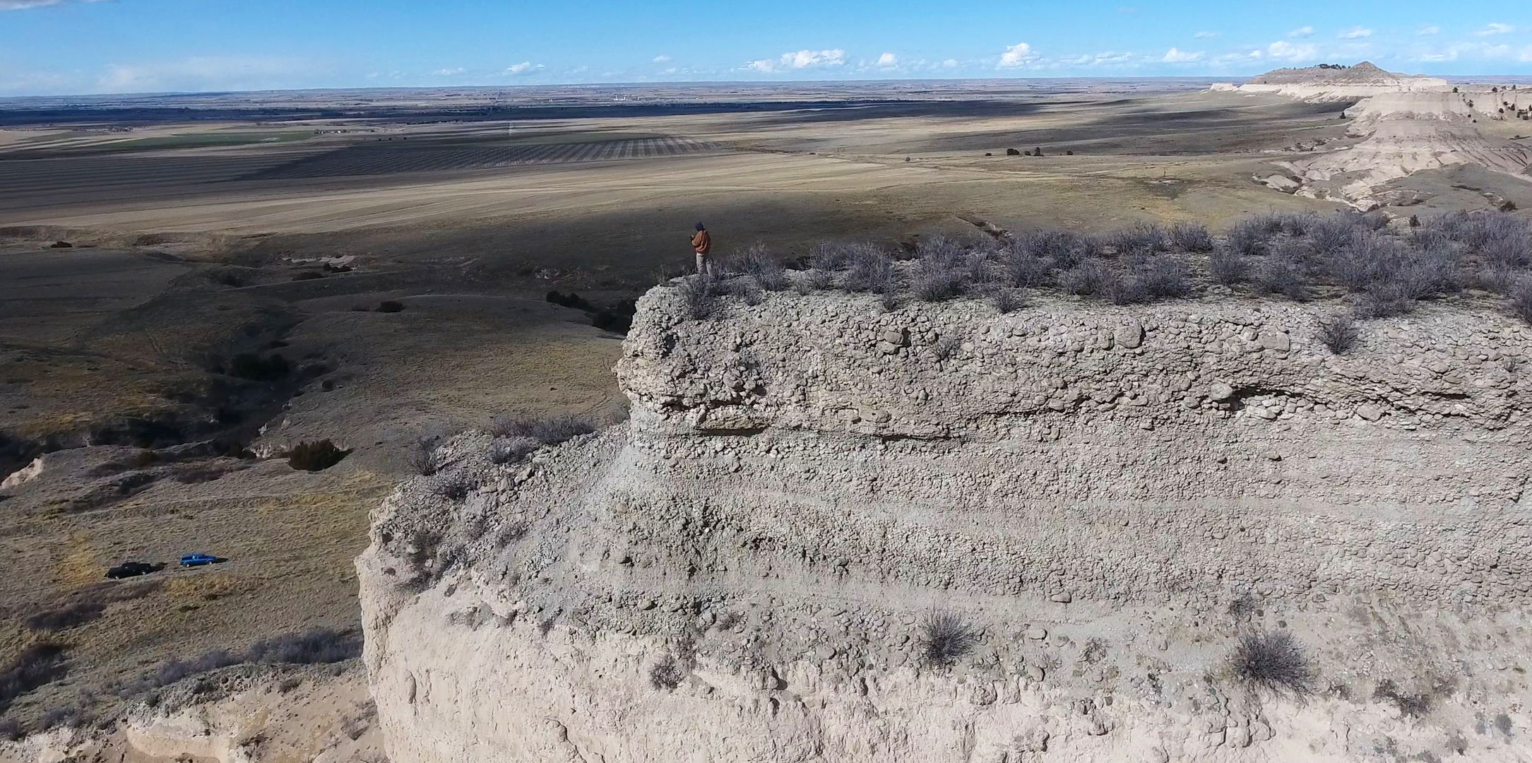
The boulders — some the size of a smart car and formed about 23 million years ago — were first documented in 1903 by geologist Nelson Horatio Darton. But they were difficult to study due to their location about 300 feet up extreme terrain, said Jesse Korus, geologist with the Conservation and Survey Division at Nebraska. That all changed when he got his drone license in 2017, making it possible for the survey division to conduct an in-depth, detailed study of the rocks for the first time.
Over the course of a year, the team of researchers took more than 3,000 drone photographs of the geologic formation known as the Haystack Mountain conglomerate. From the photographs, they constructed 3-D representations of the cliffs or digital outcrop models.
“We also used ground-penetrating radar, which allowed us to see under the ground behind the cliffs, further enhancing our 3-D reconstruction of the rock structures,” Korus said.
Armed with this data, the researchers were able to build models they could use to analyze and interpret what happened to the land millions of years ago to leave the boulders behind.
The Haystack Mountain conglomerate is a bed of sloping layers made of sandstone formed under water at least 80 feet deep. But before that, it was an ancient landscape in a narrow river valley, a riverbed of loose sand and hard sandstone concretions that the river cut into over time. As the river eroded the bed and valley walls, the loose sand washed away, leaving the hard cobbles and boulders.
And then, the researchers think, powerful, deep floods moved through, pushing the boulder material downstream in giant bars.
“These bars may have resembled the fields of ice boulders we saw last spring after the floods of 2019, except the boulder deposit didn’t melt like the ice did,” Korus said. “Instead, they become consolidated into conglomerate rocks and were eventually uplifted, forming cliffs that are now part of the modern landscape of the Wildcat Hills.”
Though the researchers don’t know what factors ultimately drove the evolution of the Haystack Mountain conglomerates, some factors may have been tectonic uplift, climate change, ecosystem change from forest to grassland biome, or even the erosion of a stream headwaters into a neighboring watershed resulting in an instantaneous river-system change.
Future studies using drone work and 3-D models of similar river deposits nearby, or at different locations and geologic ages across the Great Plains, could answer those questions and will be pursued in the future.
“We want to understand the long-term evolution of river systems on the Great Plains as context for understanding modern large floods, river deposits, and potential impacts of climate change on river hydrology and sedimentology,” Korus said. This study is the first in building the understanding of the destructive power of floods and what may be possible in the future.
Other researchers on the project included Matt Joeckel, director of the CSD at the School of Natural Resources, and Shane Tucker, highway salvage paleontologist of the University of Nebraska State Museum, both at Nebraska.
“It is difficult to relate just how noteworthy the Haystack Mountain conglomerate is,” Joeckel said. “Its characteristics truly stand out relative to the sedimentary strata above, below, and around it in the southern Panhandle and adjacent parts of Colorado and Wyoming. It has intrigued a succession of capable geologists for some 120 years.
“Our paper, though, is the first published, comprehensive study of the deposit, and it would never have happened without Jesse’s mastery of modern techniques.”
The research was published in the Journal of Sedimentary Research and funded by a five-year Hatch Project grant from the U.S. Department of Agriculture National Institute of Food and Agriculture.
Shawna Richter-Ryerson, Natural Resources