Many Midwesterners who lived through 2019 have deeply personal memories of how record flooding changed their lives last year. A special report published this month by the High Plains Regional Climate Center helps to quantify how many precipitation and flooding records were set across the Missouri River Basin during that span.
The report was co-authored by Natalie Umphlett of HPRCC, Doug Kluck with the National Oceanic and Atmospheric Administration and Dennis Todey with the U.S. Department of Agriculture. Umphlett, a regional climatologist with the Center, located at the University of Nebraska-Lincoln School of Natural Resources, said that the team knew early in 2019 that they would seek to show how region-wide the effects of record precipitation and extensive flooding were.
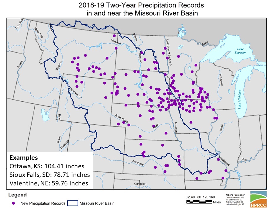
The 10-state region that the team studied includes Nebraska, South Dakota, North Dakota, Minnesota, Iowa, Missouri, Kansas, Colorado, Wyoming and Montana. Beginning late in 2018, heavy precipitation fell and began to accumulate in much of the region. Then, in March, the “bomb cyclone” event occurred, leading the Missouri River and its tributaries to reach above flood stage, where they stayed for much of the year. In some areas of South Dakota, Umphlett said, the flooding still hasn’t stopped.
“Impacts from the heavy precipitation and subsequent flooding were widespread," the authors write. "Communities were evacuated. Farmland was inundated. Critical infrastructure, such as roads, bridges, and levees, were damaged or destroyed. The mental toll from these events is ongoing. Ultimately, 16 major disasters were declared across the region due to the weather and climate events of 2019.”
According to the report, over 50 record river crests were set in the region, as were over 125 precipitation records. Umphlett said she expected to see those high numbers when she began collecting data about 2019, but she said the numbers of consecutive days in flood that cities and towns in the basin were flooded showed just how wet the conditions were last year. In Nebraska, Brownville (271 days), Nebraska City (270) and Rulo (272) set records last year. Along the James River in South Dakota, many locations continue to experience flooding.
The report is a six-page summation of the significant wetness records that were set in the region last year. While it focuses on climate data, Umphlett said that there are many more impacts that will be calculated in the coming years.
“Hearing the different ways that people have been impacted by the extreme wetness and flooding is heartbreaking,” Umphlett said. “When longer-term flooding happens, you have to wait for floodwaters to recede and for the soil to dry out. I think this waiting game really wears on people, especially when it’s a matter of weeks and months. Many of these impacts are ongoing today and some may not be realized until much later. We could write a whole book about what happened last year.”
The report, titled “Extreme Wetness of 2019,” is available online at: https://hprcc.unl.edu/pdf/2019Extremes.pdf
More details at: https://hprcc.unl.edu/pdf/2019Extremes.pdf