Rob Shepard, a geography Ph.D. student working with the Center for Digital Research in the Humanities, has played a key role in developing the interactive map on the Civil War Washington web site which is now in the spotlight because April 16 is the 150th anniversary of the Compensated Emancipation Act.
“Web design is not the same as cartography,” Shepard said, “but it’s kind of invaluable to be able to deliver this kind of information this way.”
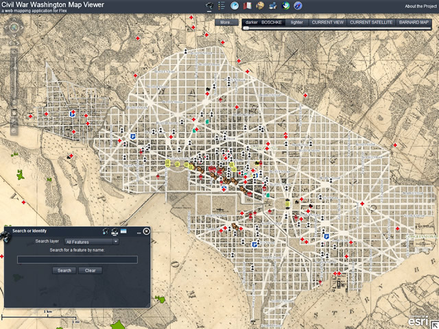
The map viewer (http://civilwardc.org/maps/flex/) offers many options and promotes exploration of historic data. For instance, using the time slider under “more” with the hospitals layer shows how hospitals moved within the city during the decade of the 1860s. Future research will enable similar comparisons over time of the locations of theatres, government buildings, churches, bawdy houses, freeman’s villages and other features.
Using the slider at the top right to change base maps shows large-scale development patterns over time, notably the filling of the Potomac and surrounding wetlands. The Jefferson Memorial and webs of highways are now on ground that was river and marsh.
One of Shepard’s first tasks when he began working with the project in August 2011 was to create a precisely georeferenced base map. Shepard said the original map at the Library of Congress appeared to have been pieced together, with gaps between pieces and creases introducing spatial error. In order to get a map that was sufficiently accurate for the time slider, Shepard had to divide the base map into components, georeference each one, and then merge the images back into a single base map.
He established 500 ground-control points, knowing, for example, that the four corners of the White House would be in the exact same spot over time, and that the street grid had stayed much the same over time. He also matched the U.S. Census Bureau’s TIGER centerline file with the base map, and worked with aerial photography to align locations precisely. To read more about the map, visit http://civilwardc.org/maps/about/
In addition to putting final touches on the mapping application, Shepard is working with the research team to edit locations of various facilities as scholars learn more. The map viewer has 17 data layers in addition to the base maps.
Shepard, who is advised by David Wishart, said that after this project, he is considering incorporating a web aspect into his dissertation research. He said, “Learning how to do this type of work is crucial to a lot of projects, and web GIS is an important medium for communicating geographic information to the public.”
UNL scholars associated with the Center for Digital Research in the Humanities (http://civilwardc.org/about/participants.php) transcribed petitions from slave owners who were requesting compensation for their slaves’ freedom, which became possible under the Compensated Emancipation Act. The petitions document of the lives of slaves and provide a valuable glimpse of life at a pivotal time and place in the nation’s history.
More details at: http://www.youtube.com/watch?v=Ot7jaYEDySA&feature=youtu.be